|
|
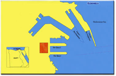
Dekhila Port
|

|
|
 |
| |
|
|
UNCTAD Code: EGEDK
Long: 29 o 49/ E Lat: 31 o 08/N
Time Zone GMT +2
Wave Code (VHF) 9 11 13 16
Port’s Compliance with ISPS
Identification number 17350
Acceptance date 17/6/2004
Natural Characteristics
Weather Prevailing winds are North West
Wind Scale 2-3 Beaufort (in summer),3-4
Beaufort (in winter)
Water Density 1.030 (g/cm2 )
Raining Season Winter
Tidal range and flow 0.46 m.
|
|
Port Description |
|
Location
Dekheila port is a natural extension to Alexandria Port;
constructions started in 1980 and the port became
operational in 1986 with the operation of the minerals
berth. Dekheila port takes the place of the former Dekheila
airport
westward Alexandria port,
7 km. distanced from sea and 10 km. from land
|
|
Geographical Overview |
| |
The site is characterized by:
·A
bay with high depths near the sea side, which lowers the
decontamination cost. The north side is shallow and includes
some small is lands serves in lowering the costs of
breakwater when constructed.
·A
sandy region, which save debris and building costs.
·Easy
linking to the local ways (desert road Alexandria/Egypt) and
the railways.
·The
land area is suitable for any future development plan as
well as any projects for establishing a logistics area.
·Port
location is near Dekheila Solid convention and the free zone
and the project of Electricity Generation of West Alexandria
which save the cost of the needed are transportation
|
|
Port Specifications |
| |
Engineering Features
Total Area 6 sq. km.
(approximately)
Water Area 280 sq. km.
Land Area 3.2 sq. km.
Productivity Features
Maximum Capacity 20.37
million ton/year
General Cargo 6.10 million ton
Dry Bulk 6.41 million ton
Liquid Bulk 4.21 million ton
Containerized Cargo 3.66 million ton
TEU Capacity 500000
Max. Ship Size 168000 GRT
Max. Ship Length 304.8 m
Max. Ship Width 42.67 m
Max.
Depth 18.89
m
Working Hours 24 h. (scheduled time)
|
| Navigation
Rules |
|
Approach Area
Navigation Channels
1.5 mile length, 250 m. width, 20 m. depth.
Turning
Circle
750 m. diameters, 20 m. depth for vessel maneuvering.
Main
Breakwater
To protect the port from widespread waves progressing from
the North West 2250 m. long. The breakwater extends from
Agamy throughout the several natural island, and consists of
concrete – reinforced stones. The breakwater Chart datum
varies from 2.77 m. to 5.8 m., reaches a depth between 10,
12 and the side sloping is 2 : 1
Pilotage
Following Alexandria Port applicable regulations.
|
|
Berths |
|
Berth Type |
Number of Berths |
Auxiliary Berths |
Length (m.) |
Depth (m.) |
|
From |
To |
|
Oil |
4 |
91/A, 91/B, 91/C,
98\2 |
842 |
11.9 |
13.6 |
|
Minerals |
2 |
90/1, 90/2 |
640 |
14 |
18.90 |
|
Grains |
5 |
92, 94/1, 94/2,
94\3, 94\4 |
1281 |
11.6 |
14 |
|
Container |
3 |
96/1, 96/2, 96/3
|
732 |
11. 9 |
11. 9 |
|
Multi- purpose |
3 |
96/4,
98/1, 98/3 |
579 |
10. 7 |
11.9 |
|
Total |
17 |
|
4074 |
|
|
|
|
|
|
|
|
|
|
|
|
|
|
|
|
|
| Contacts |
|
Address Dekheila Port Authority (Affiliated to
Alexandria Port Authority) 106 El-Horreya Avenue.
Telephone 3091852-3091858 (6 Lines)
Fax 3088286
Telex APA UN 54310
Email
alxsite@emdb.gov.eg
Website www.mrcc.aast.edu/ports/alexandria
|
|