Suez Port


UNCTAD Code: EGSUZ
Long: 32 o 34/E                 Lat: 29 o 56/N

Time Zone                   GMT +2

Wave Code (VHF)       12 - 16


Port’s Compliance with ISPS
 

Identification Number     14928

Date of Approval            24/6/2004


Natural Characteristics
 

Weather                   Prevailing winds are north and north west.

Water Density           1.04 (g./cm2)

Raining Season         Winter

Tidal range and flow  2.1 m. to 1.2 m.


Port Description


Location

Suez Port is located at the southern boundary of Suez Canal. It is bordered by the imaginary line extending from Ras-El-Adabieh to Moussa sources including the North Coast until the entrance of Suez Canal.


Geographical Overview
 

Ibrahim Dock Bordered by an imaginary line extending between the two breakwaters.

Petroleum Dock Bordered by an imaginary line extending 140 degrees from the extremity of the eastern breakwater until the western breakwater.

Ataka Port The boundaries of Ataka Port are delimited by the port breakwaters.

The water out of the boundries of Ibrahim Dock, Petroleum Dock, Ataka Port, Adabiya Port and New Petroleum bert is within the Suez Canal values.


Port Specifications


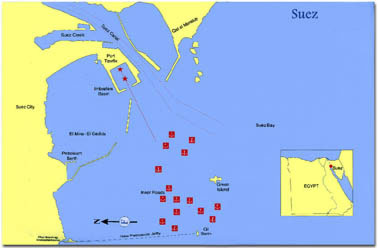
Engineering Features
 

Water Area                       158073000.km (Including Suez, Adabiya, and Petroleum Dock)

Land Area                         314426.km                    

Total Warehouses Area      10115 sq. m.

Total Yards Area                13476 sq. m.

Navigation channels length  1000 m

Navigation channels depth   12 m 


Productivity Features
 

Maximum Capacity     6.60 million ton/year as follow

                                         6.60 million tons (general cargo)

                                        1.5 million Passenger

Maximum Ship Received

Vessels with draft 8 m and 150 m  length

Working Hours     Throughout 24 hours (in 3 shifts)


 Navigation Rules
 

Approach Area
 

Vessels usually berth at the dwelling area. Dredging of the fairway at new Sakhra port and the coastal cape has rendered water depth consistent, estimated at 11.28 m. During tide, vessels up to 11.25 m. draft can approach the harbour during the flow taking the consideration that the draft not exceeding 12.19 m


Pilotage
 

Pilotage is compulsory, and it is monitored though radio (VHF – H/F) and electronic  equipment (Radar Beacon).

Information about pilots
 

Pilot Rank

Pilot Number

Senior Pilot

6


Berths
 

Berth Type

Number of Berths

Length (m.)

Depth (m.)

From

To

Passenger

5

750

8.00

8.00

Passenger / cargo

7

1320

7.5

7.5

Total

12

2070


Contacts


Address          Suez Port, Port Tawfik – P.O. Box: 1

Telephone       + (20) 62 331124 - 331123

Fax                 + (20) 62 331120 - 331117

E-Mail             redseaut@idscl.gov.eg